Al-Shariyah: Military Expert Suggests Explosion of Stored Materials Inside Homes as Researcher Points to Tunnels Linking Village to Mountain
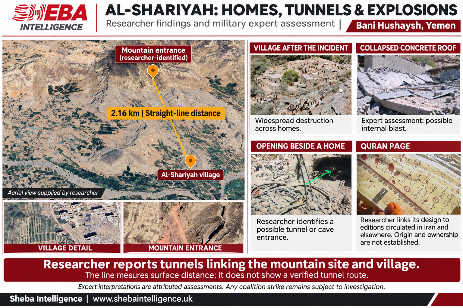
Materials provided to Sheba Intelligence highlight the possible use of homes to support underground facilities, exposing residents to the dangers of weapons and explosions.
A military specialist collaborating with Sheba Intelligence believes an explosion inside Al-Shariyah village, in Bani Hushaysh district east of Sanaa, caused a substantial portion of the destruction to its homes. His assessment raises the possibility that highly explosive materials were present inside some buildings, alongside information supplied by a researcher about tunnels connecting homes and nearby sites to facilities inside the mountain.
The assessment places the alleged Houthi use of residential areas for military activity at the center of its explanation of the incident. It considers the possibility that some buildings served as storage sites or access routes to underground facilities, exposing their occupants and neighboring households to the risk of explosions.
The expert based his assessment on ground-level photographs of the destruction, footage broadcast by Houthi media, and map imagery and coordinates supplied by the researcher showing buildings adjoining rocky slopes and a mountain site accessible by dirt roads and cleared areas.
Homes and Passages Toward the Mountain
According to the researcher, tunnels run between the village and the nearby mountain site, while one house connects to a tunnel leading toward the mountain. He supplied images of the building and the connection point he identified, alongside images of openings at the base of the cliff.
One frame from Al-Masirah television shows a large dark cavity beside a damaged house, with timber and rubble in front of it. The expert considers it a possible entrance to a cave or tunnel adjoining the house or forming part of its associated structures.
In the expert’s assessment, these details raise the possibility that residential buildings served as access points to underground facilities, placing military infrastructure within the civilian environment.
The researcher identified a tunnel entrance at 15°30′54″N, 44°21′41″E. The straight-line distance between that location and the supplied village reference point is approximately 2.16 kilometers, almost due north.
He also identified another location within the same mountain site, approximately 86 meters from the entrance. Images show branching dirt roads, areas cleared at the foot of the mountain, and excavation and earthworks that the researcher associates with facilities he says support the tunnel network.
Collapsed Roofs and Blast Pressure
In examining the destruction, the expert focused on an image of a large concrete roof slab that had fallen close to ground level, with substantial sections remaining relatively intact despite cracks and fractures.
He said the collapse pattern led him to favor the possibility that pressure from an internal explosion destroyed the building’s supporting elements, causing the slab to fall. He also noted its apparent thickness and the importance of understanding the building’s construction and reinforcement.
The expert compared this image with the wider scene, which shows collapsed buildings and rubble extending down the slope alongside homes that remained partially standing. In his assessment, a powerful blast wave from a building containing explosive materials could explain damage to neighboring homes that did not necessarily contain weapons.
He added that he could not identify a clear impact crater in the images he reviewed, a point he incorporated into his assessment favoring an internal or near-ground-level explosion.
The expert proposes two possible explanations for the initial explosion: the detonation of materials stored at the site, or a missile-related incident. In either case, his assessment focuses on the danger created by military activity amid civilian homes.
Different Damage Patterns and a Possible Subsequent Strike
Another image shows a partially standing building with localized damage to its facade and damage to its upper covering. The expert considers this pattern different from the extensive collapses visible elsewhere and raises the possibility that the building was struck by a projectile.
On that basis, he proposes a sequence beginning with an explosion inside the village, followed by a subsequent strike on the site. Whether the coalition conducted a strike, and its timing and intended target, remains dependent on the investigation findings announced by the relevant authorities.
Questions About the Displayed Metal Object
The review also included an image of a cylindrical metal object partially exposed amid soil and rubble, presented as an unexploded aerial bomb.
The expert questions the circumstances of its appearance and positioning, citing its nearly horizontal placement inside the cavity. He raises the possibility that it was moved there for filming to support the account that all the destruction resulted from airstrikes.
This represents the expert’s challenge to how the scene was presented in the media. The original recording, the object’s markings, and documentation of its discovery are therefore important to understanding its connection to the incident.
The Quran Shown in Houthi Media Coverage
The researcher also supplied an image of a damaged Quran page shown in Houthi media coverage. The page displays the name of Surah Ad-Dukhan inside a dark rectangle in the margin, alongside a decorative border and verse markers.
The researcher associates this design with editions circulated in Iran, Iraq, Syria, and Lebanon, and presents it as one of the indicators that prompted him to examine a possible Iranian connection to the site. This interpretation is attributed to the researcher: the image does not show the publisher or country of printing and does not establish the identity of the Quran’s user.
Civilians Paid the Price
In an update issued on the evening of November 8, the Houthi-run Health Ministry reported 44 people killed, including 21 children and 10 women, and 40 others injured, following earlier, lower casualty figures. These figures remain attributed to the authority that announced them.
The expert’s assessment centers on the possibility that residents suffered the consequences of buildings within their residential area being used to store military materials or support mountain facilities, with the explosion affecting neighboring homes and people unconnected to military activity.
The information supplied by the researcher, together with the expert’s interpretation of the images, places alleged Houthi responsibility for exposing civilians to danger at the forefront of this report: from the possible use of homes as tunnel entrances, to the potential presence of explosives inside buildings, and the concealment of military activity from surrounding residents.
Pending the findings concerning any coalition strike, the alleged military use of homes and facilities near the village remains the central explanation advanced by the researcher and expert for the scale of the disaster in Al-Shariyah.